Details
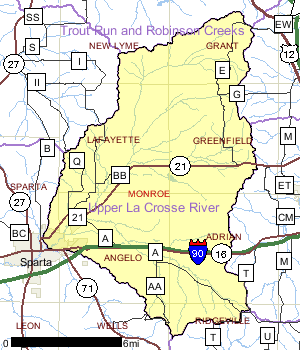
The Upper La Crosse River Watershed covers approximately 126 square miles, 57% of which are contained within the Fort McCoy Military Reservation. Many streams in this watershed originate outside the boundaries of Fort McCoy, but then flow through the military installation, eventually reaching the La Crosse River. Much of the reservation is used for military training including: firing ranges, classrooms, air-to-ground impact area, airborne drop zones, and multi-purpose training ranges. The vegetation, terrain, and water resources available within Fort McCoy allow a varied training experience. At times, training exercises can directly or indirectly impact natural resources. Conversely, management of the natural resources of Fort McCoy can have both positive or negative impacts on training activities. To that end, Fort McCoy staff completed an integrated natural resources management plan in 2000 to summarize the natural resources of the Fort and identify major natural resource initiatives.
Since 1993, the Fort McCoy Fisheries Program has been assessing the water quality, habitat, macroinvertebrates and fisheries of the streams and lakes within Fort McCoy. The data collection and analysis methods are either the same or very similar to Wisconsin Department of Natural Resource (WDNR) methods. The sharing of information, ideas, and cooperative agreements between Fort McCoy, the Monroe County Land Conservation Department and WDNR have resulted in increased knowledge and improvement of many streams and lakes in Monroe County.
Measures taken by Fort McCoy to reduce impacts to the water and land resources from training activities include: rehabilitating training areas to promote revegetation and reduce erosion; use of streambank erosion protection measures; require tracked vehicles to cross waterways at designated bridges or culvert crossings; establish a no-fire corridor along the La Crosse River in the North Impact Area; conduct fishery surveys; adhere to new federal non-point source erosion control policies for new construction; analyze solid waste management units to determine possible groundwater and surface water contamination and appropriate remediation; and remove underground petroleum product storage tanks.
Date 2002
Nonpoint and Point Sources
Since the majority of stream miles in the Upper La Crosse River Watershed lie within Fort McCoy, where less non-point source pollution occurs relative to agricultural lands adjacent to the military reservation, the non-point source rank for the entire watershed is low. However, grants available from the WDNR to reduce non-point source pollution cannot be disbursed to a Federal agency such as the Department of Defense - Fort McCoy. Consequently, the streams or portion of streams in the Upper La Crosse River Watershed within Fort McCoy were excluded from the ranking process. The non-point source rank of the Upper La Crosse River Watershed, excluding the stream miles in Fort McCoy, is high.
Date 2002

Ecological Landscapes
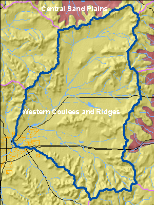
This watershed is located in the Western Coulee and Ridges Ecological Landscape in southwestern and west central Wisconsin and is characterized by its highly eroded, driftless topography and relatively extensive forested landscape. Soils are silt loams (loess) and sandy loams over sandstone residuum over dolomite. Several large rivers including the Wisconsin, Mississippi, Chippewa, Kickapoo and Black flow through or border the Ecological Landscape.
Historical vegetation consisted of southern hardwood forests, oak savanna, scattered prairies, and floodplain forests and marshes along the major rivers. With Euro-American settlement, most of the land on ridgetops and valley bottoms was cleared of oak savanna, prairie, and level forest for agriculture. The steep slopes between valley bottom and ridgetop, unsuitable for raising crops, grew into oak-dominated forests after the ubiquitous presettlement wildfires were suppressed. Current vegetation is a mix of forest (40%), agriculture, and grassland with some wetlands in the river valleys. The primary forest cover is oak-hickory (51%) dominated by oak species and shagbark hickory. Maple-basswood forests (28%), dominated by sugar maple, basswood and red maple, are common in areas that were not subjected to repeated presettlement wildfires. Bottomland hardwoods (10%) are common in the valley bottoms of major rivers and are dominated by silver maple, ashes, elms, cottonwood, and red maple. Relict conifer forests including white pine, hemlock and yellow birch are a rarer natural community in the cooler, steep, north slope microclimates.
Date 2010
Recreational Opportunities
Access to streams and lakes within Fort McCoy for fishing and recreational purposes is granted by permit from the Fort McCoy Directorate of Training and Mobilization. A WDNR fishing license and State Trout Stamp are required as well as a Fort McCoy Fishing Permit. Fishing regulations and access are unique to the military installation and enforced by the Fort McCoy Directorate of Protective Services. Specified areas are closed to recreational activities for safety or security purposes. Information related to recreational opportunities within Fort McCoy can be obtained online at: http://www.mccoy.army.mil/
Date 2002
Monitoring & ProjectsProjects including grants, restoration work and studies shown below have occurred in this watershed. Click the links below to read through the text. While these are not an exhaustive list of activities, they provide insight into the management activities happening in this watershed.

Priorities
1/1/2016
Work with collaborators to initiate the TMDL for Both Squaw Creek and Stillwell Creek, which are classified as water quality-limited and have been placed on Wisconsins list of water bodies in need of restoration, a list prepared in accordance with Section 303(d) of the Clean Water Act and known as the 303(d) list.
Watershed RecommendationsConfirm FCA: IW pre-2000 data
Date
Status
11/8/2011
Proposed
Date
Status
WDNR staff should continue to encourage communities to develop wellhead protection plans in the Watershed and the whole basin.
7/1/2010
Proposed
Stillwell and Squaw Creeks TMDL
Date
Status
This is a U.S. EPA initiated and approved TMDL. Squaw Creek and Stillwell Creek are tributary streams of the Upper La Crosse River Basin, located in Monroe County in west-central Wisconsin. The streams are within the boundaries of Fort McCoy, a federal military facility. Both Squaw Creek and Stillwell Creek are classified as ?water quality-limited? and have been placed on Wisconsin?s list of water bodies in need of restoration, a list prepared in accordance with Section 303(d) of the Clean Water Act and known as the ?303(d) list.? The Wisconsin Department of Natural Resources (WDNR) listed Squaw Creek due to temperature impairments. WDNR listed Stillwell Creek due to temperature and sediment impairments. Stillwell Creek was added to the 303(d) list in 2003, but there was an error in listing the precise segment of the creek. The State of Wisconsin has since provided information to USEPA to correct this information.
10/1/2006
In Progress
Nine Key Element Plan or TMDL
Date
Status
A nine key element plan might be created for this area with cost share funding for BMPs through grant programs.
7/14/2014
Proposed
 Watershed History Note
The Upper La Crosse River Watershed covers approximately 126 square miles, 57% of which are contained within the Fort McCoy Military Reservation. Fort McCoy has played an important role in the history of the State of Wisconsin.
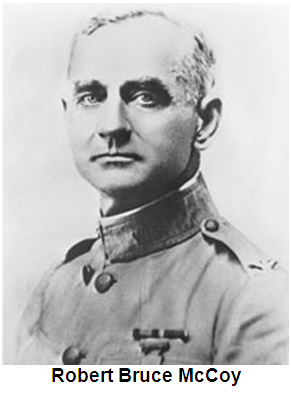
The idea of using the land east of Sparta as an artillery range was conceived by Robert B. McCoy. Upon returning from the Spanish-American War, McCoy envisioned an artillery camp, suitable for training Soldiers, situated in the low pastures and wooded hills surrounding Sparta. He started by buying small tracts of land, which he rented for grazing to finance additional land purchases. Eventually, he acquired 4,000 acres. Major Samuel Allen, commander of the 7th Field Artillery, Fort Snelling, Minnesota, also admired the terrain of the Sparta area for its training value. In September 1905, Robert B. McCoy invited Allen�s unit, along with an Army board of reviewing officers, to put the land to the test during 16 days of training on his family�s ranch.
By 1909 the United States government had purchased both the ranch and acquired another 10,000 acres to create two military camps. In 1910, $40,000 in additional improvements were authorized. Construction was aimed at making the site permanent, and the camp was named Camp Bruce Elisha McCoy, after Robert Bruce McCoy�s father. It continued to grow through World War I with the construction of barracks, mess halls, stables and warehouses. Field artillery units trained at the camp during World War I through 1918.
Between 1919 and 1933 it was used as a Field Artillery site, an Ordnance Depot, and a Citizen�s Military Training Camp. On Nov. 19, 1926, the reservation officially was designated as Camp McCoy in honor of Maj. Gen. Robert B. McCoy, who had recently died. From 1933 to 1935 the camp was used by the Civilian Conservation Corps as a supply base. Between 1938 and 1942 another 45,000 acres were added and 1500 buildings were constructed. During WW II Camp McCoy was used to house Japanese, Korean and German prisoners of war. Between the end of the WW II and 1965 the camp was deactivated and activated multiple times for different types of activities including a cold weather training camp in 1946 to test winter clothing and equipment and a Job Corps Training Center from 1966 to 1968.
In 1974 the camp was designated a year round training facility and was renamed Fort McCoy. In May 1980, Fort McCoy was designated as a Resettlement Center for Cuban refugees who came to the United States when Fidel Castro allowed them to leave Cuba as part of the �Freedom Flotilla.� Approximately 15,000 Cubans were housed here through October. Since then Fort McCoy continues to play an important role in our nation�s military history.
Date 2010